
Bike Trails
Are you looking for an excellent resource for where to ride in the Yosemite area? Well, look no further! Explore 29 mountain biking options below. Better yet, stop by Pedal Forward Bikes & Adventure, and we’ll personally recommend where you should ride based on your skill level.
We recommend using the Trailforks app to help you navigate these trails, as most of the trails below can be found on Trailforks. Visit https://www.trailforks.com for more information, or download the app to your smartphone or tablet. Also, consider watching our trail and Featured Feature videos on our YouTube channel.
Tap the button below to access our Interactive Trail Map and to see current Trail Conditions.
Mountain Bike Trail Descriptions
The Yosemite Southgate area is a mountain biker's paradise, offering world-class trails that are a true hidden gem in California. Just a short drive from our shop in Oakhurst, you'll find Bass Lake, which features a diverse range of singletrack mountain biking trails and scenic fire roads perfect for gravel biking. Below, you'll find a list of our local trails, complete with descriptions to help you explore this incredible terrain. Many trails are unmarked, making navigation a bit tricky – but don't worry! Pedal Forward offers guided mountain bike rides tailored to all levels, from serene to extreme. Click the button below to explore our guided ride offerings and get ready to experience the best of Bass Lake and beyond.
Mountain Bike Trail Descriptions
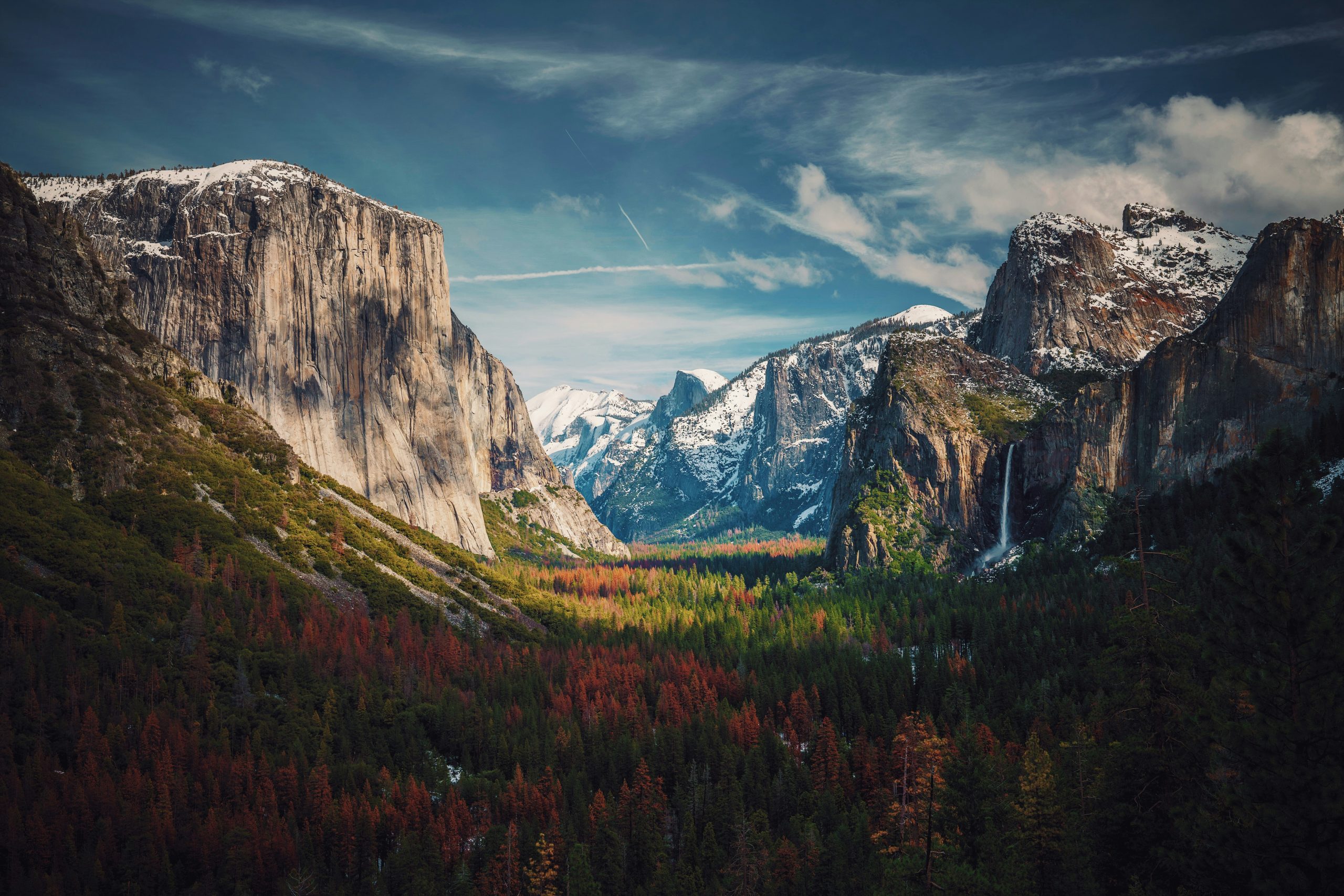
Distance: 13 miles
Trail Usage: Walking & Biking
The Yosemite Valley Loop Trail offers a stunning and accessible ride through one of the most iconic landscapes in the world. This scenic, mostly flat loop spans about 13 miles and takes you through Yosemite’s breathtaking valley, surrounded by towering granite cliffs, cascading waterfalls, and lush meadows. You'll ride past famous landmarks like El Capitan and Bridalveil Fall, all while enjoying the serenity of the park's natural beauty.
Renting bikes from Pedal Forward Bikes & Adventure makes exploring the loop even more enjoyable. With our comfortable, high-quality bikes, you’ll have the perfect ride for this leisurely trail, allowing you to take in the sights at your own pace. Whether you're a seasoned cyclist or just out for a relaxing day, the Yosemite Valley Loop Trail offers an unforgettable experience, with plenty of spots to stop, rest, and soak in the stunning views. It's the perfect way to explore the valley’s wonders while making memories that will last a lifetime.
Distance: 2 miles
Trail Usage: MTB – Downhill Only
The 007 First section is a thrilling, fast descent full of rock gardens. However, be cautious when navigating the ruts toward the bottom. While various lines are available, it is essential to select your path carefully, especially around the rock gardens.
The trail's flow is enjoyable, but be mindful of occasional dirt bike traffic. The section provides a fantastic mix of challenges with tight lines to test your skill.
Distance: 1 mile
Trail Usage: MTB – Both Ways
007 Second is a mix of technical rock gardens and flowy singletrack. Riders have three options:
- Proline Trail: Connects with the 007 First section.
- Long, chunky rock garden descent: For intermediate to advanced riders.
- Fire road access to 007 First or technical routes: A good alternative if you're looking for a challenge.
Watch for traffic on the fire road and prepare for a rugged, technical adventure through the rocks.
Distance: 0.5 miles
Trail Usage: MTB – Downhill
Octopussy offers an alternative to the 007 Third section. The trail starts with an exhilarating, wide-open descent before narrowing into tight turns and a challenging rock garden. There are numerous lines to choose from, and first-timers should carefully plan their path.
The trail flows fast and fun, with jumps, natural berms, and sneaky rock sections leading to Central Camp Road.
Distance: 1 mile
Trail Usage: MTB – Downhill
007 Third starts with some climbing before rewarding riders with fast, flowing singletrack, including berms and tight switchbacks. The trail culminates in the steep and technical "waterfall" rock garden—test your skills here!
Distance: 2.5 miles
Trail Usage: MTB – Hiking – Trail Running
- 007 Fourth: A mix of climbs and descents, including an "elevator shaft" pitch and a granite creek crossing. The descent features pump-track-style bumps.
- 007 Fifth: A challenging section with steep rock gardens and fast, flowy singletrack.
- 007 Sixth: Connects 7-Mile Junction with the top of 007 Fifth—a rugged, remote section with steep climbs and descents.
.
Distance: 2.6 miles
Trail Usage: MTB – Hiking – Trail Running
The Goat Mountain—Ninja section of the 7-mile Bass Lake loop offers scenic views and challenges for all skill levels. The trailhead begins at the back of Forks Campground, next to Forks Resort.
From here, the trail climbs steeply to Goat Mountain’s saddle, where you can choose:
- Left: A thrilling, rocky descent down the "Ninja" section.
- Right: Continue to the Goat Mountain Fire Lookout for 360-degree Sierra views.
Expect some technical, rocky sections in the upper trail, but the reward is worth it: fast, flowing singletrack. The "Ninja" is a playful, fast descent full of berms and tight turns, while Spring Cove provides a fun and rocky descent alternative.
Distance: 2 miles
Trail Usage: MTB – Hiking – Trail Running
Spring Cove offers a fun alternate descent from the Goat Mountain Trail. From the junction, riders can opt for a speedy ride down Spring Cove. Watch for fire road crossings when descending Spring Cove, especially in the lower sections.
After riding down Spring Cove, you can enjoy a technical climb back up Spring Cove to the junction and then ride down the rest of the Goat Mountains Nija Trail. Otherwise, you can ride back to the parking area on the road that meanders next to Bass Lake.
Spring Cove can be combined with other trails like Goat Mountain and 007 for longer rides. Take care around fire road intersections; otherwise, it’s a smooth, scenic trail with great flow.
Distance: 3 miles
Trail Usage: MTB – Hiking – Trail Running
This trail offers an exciting route to the summit of Goat Mountain and its iconic Fire Tower. Take North Fork Road 42 from Oakhurst, pass the fire station and Hidden Meadows Road, and continue straight. Turn left onto a fire road, and you'll find a green gate marking the trailhead.
As you ascend, you'll come to an intersection with two options:
- Left: Tackle the steep Goat Mountain trail leading directly to the summit.
- Right: Follow the fire road to the lookout tower, passing scenic meadows. Watch out for sandy patches along the way.
The summit promises rewarding panoramic views, and the descent is an exhilarating ride back down. For more trail options, this route connects with Goat Mountain and Spring Cove Trails, allowing for custom routes. A heads-up: bug spray may be necessary, depending on the season!
Distance: 0.2 miles
Trail Usage: MTB – Downhill
Pro-line is a short but steep connector designed to bypass part of the rock garden. Expect loose gravel at the top and a sharp left turn before entering the 007 Second section.
Distance: 1 mile
Trail Usage: MTB – Hiking – Trail Running
Add Graham Dome to your 007 ride for a rewarding granite dome overlooking of Bass Lake. The fire road climbs through scenic meadows and creeks, leading to a picnic-worthy spot at the top of the dome.
Distance: 3 miles
Trail Usage: MTB – Hiking – Trail Running
Blind Squirrel is a hidden gem with unique features reminiscent of Sedona or Utah. We highly recommend booking one of our guided rides for this trail as it is very easy to get lost. There are also blind drops and additional hazards on this beautiful ride.
The ride begins with a climb on Central Camp Road, followed by a turn onto 7S02 fire road. There are two trailheads, one with an intense climb and the other marked by cairns. This trail weaves through a forest of boulders and leads to Lost Forest Trail before dropping down a steep granite slab with jaw-dropping views. Keep track of the trail map, as getting lost in this stunning terrain is easy.
Distance: 1.5 miles
Trail Usage: MTB – Hiking – Trail Running
Skyfall takes you up to the peak of Shuteye Mountain, the highest elevation in the area, for stunning 360-degree views. After signing the guestbook at the fire watch station, the descent is an exhilarating mix of loose rock and technical sections, transitioning to a fun, flowy trail under the trees.
Distance: 3 miles
Trail Usage: MTB
Lumberjack is a smooth, flowy trail that weaves through shaded trees at a high elevation, offering a North Shore-like feel. The descent takes you from 7,000’ to 5,500’ and connects to LoJack. The trails are linked by Fire Road 6S08 and have a secretive local vibe. Go with someone familiar with the trails to avoid potential dirt bike traffic.
Distance: 2 miles
Trail Usage: MTB – Hiking – Trail Running
Mary Jane is one of the most iconic trails in the area, shaped by an unexpected detour around a pot farm. The trail descends steep rock slabs and features thrilling drops, bowls, and rolls.
Expect amazing views of Bass Lake as you ride through the forest and loose sections. It ends at Willow Creek Fire Road, where you can either head back to Bass Lake or start the technical climb to Willow Creek Trail. A seasonal bridge (log) may be available to cross the creek.
Distance: 2 miles
Trail Usage: MTB – Hiking – Trail Running
Willow Creek is a double black diamond downhill trail best suited for full-suspension bikes with at least 130mm of travel. This adrenaline-pumping trail has technical features that require sharp focus and skill. First-timers should proceed with caution. The trail offers flowy sections, rock gardens, and steep slabs, perfect for advanced riders. Afterward, be prepared for some of the best swimming holes in the Bass Lake area.
This is a sample text. You can click on it to edit it inline or open the element options to access additional options for this element.
This is a sample text. You can click on it to edit it inline or open the element options to access additional options for this element.
Distance: 1 mile
Trail Usage: MTB – Hiking – Trail Running
This double black diamond trail is steep and technical, descending to the waterfalls. It’s best to shuttle up, as climbing back is tough. The trail ends at Cedar Valley, where you can relax by the creek.
Lewis Creek is a great XC ride, offering smooth flow with occasional technical challenges. It’s also a beautiful trail for hiking and picnicking, perfect for beginner riders looking to practice their skills.
Distance: 24 miles
Trail Usage: MTB – Gravel – Hiking – Trail Running
Signal Peak is an extensive out-and-back route starting from Fish Camp. The climb is steady, followed by a thrilling descent. With views of Yosemite National Park and Wawona, this trail offers a rewarding ride for those prepared for the challenge.
Distance: 6 miles
Trail Usage: MTB – Gravel – Hiking – Trail Running
Biledo Meadow offers stunning views, wildflowers, and a variety of trail difficulty levels. Starting at Mount Raymond Rd, the journey leads to high-elevation meadows and a scenic spot for a rest. Check the map, as the last mile can be tricky for vehicles.
Distance: 10 miles
Trail Usage: MTB – Hiking – Trail Running
This challenging route is perfect for long rides and steep climbs. Starting from Goat Meadow, the route leads to Star Lakes and offers panoramic views of Yosemite and Half Dome.
Distance: 5 miles
Trail Usage: MTB – Hiking – Trail Running
Hensley Lake features fun, fast descents, jumps, and rock rolls. The local bike club has developed exciting features suitable for riders of all skill levels. This is a fantastic trail to enjoy, especially during cooler months or in winter when snow covers the trails.
Trail Usage: MTB Only
Located just 90 minutes from Oakhurst, Exchequer Mountain Bike Park offers a well-maintained, organized space with 11 trails for all skill levels. Visit their website for the latest trail maps and info.
Distance: 21 miles
Trail Usage: MTB – Hiking – Trail Running
Known for the Big Sandy Race, this trail challenges riders with a 15-mile uphill route before connecting with the Leap Loop for 21 miles. The ride takes stamina and offers exciting singletrack sections for the adventurous.
Recent Posts
-

Why Shopping at Your Local Bike Shop is a Ride in the Right Direction – Pedal Forward Bikes & Adventure
When it comes to purchasing a new bike or gear,... -

Why a Bicycle is the Perfect Gift for a Child
Why a Bicycle is the Perfect Gift for a Child (... -

Is Yosemite National Parks Mariposa Grove Open Right Now? May 2024
Yes! Mariposa Grove is open; however, the shutt... -

The Best Place to Rent Bikes to Ride in Yosemite National Park
The best place to rent bikes to ride in Yosemit... -
How can you get into Yosemite without a reservation?
Can’t get into Yosemite National Park bec...
